


Col des Aguilles

isajav
User

Length
10.1 km

Max alt
2036 m

Uphill gradient
429 m
Km-Effort
16.6 km

Min alt
1441 m

Downhill gradient
660 m
Boucle
No
Creation date :
2021-08-01 09:36:00.0
Updated on :
2021-08-01 13:18:12.343
3h41
Difficulty : Difficult

FREE GPS app for hiking
 SityTrail
IGN / Geographical institutes
SityTrail Plus
The world is yours!
About
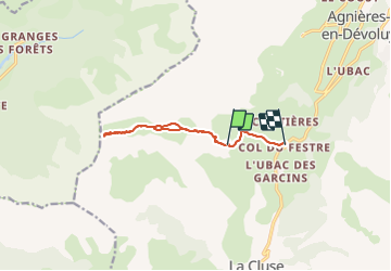
Trail Walking of 10.1 km to be discovered at Provence-Alpes-Côte d'Azur, Hautes-Alpes, Le Dévoluy. This trail is proposed by isajav.
Positioning
Country:
France
Region :
Provence-Alpes-Côte d'Azur
Department/Province :
Hautes-Alpes
Municipality :
Le Dévoluy
Location:
La Cluse
Start:(Dec)
Start:(UTM)
725071 ; 4949860 (31T) N.
Comments